
Map Unit Study for Homeschool Geography
From Sat Navs and Google Maps to paper maps, atlases, and globes this fun skills-based homeschool geography unit study is a great way to introduce your kids to the world of cartography. As your kids learn about maps, places, and more they will develop spatial awareness, how to read a map, as well as look into why maps are sometimes different all skills which they will need throughout their life. So here you go our Unit Study on Maps for your homeschool.

What Kids Will Learn in This Unit Study
In this Maps Unit Study your kids will learn about:
- Perspectives
- Symbols and Keys
- Directions
- Location including grid squares and coordinates
- Scale
- Different types of maps
- How viewpoints affect map development
Maps Unit Study
How do you feel about maps? For me they are a portal to adventure to new worlds to discovery. I love new maps, looking back through old Atlases and seeing how the world has changed, finding maps in fiction books that give us an idea of where places are set and even old maps from before places were “discovered” by European explorers. Our Map Unit study is great for getting kid familiar with maps, atlases, and the use, terms, and some of the human impact that has taken place on the designs and development.
Activities
Here are some fantastic activities for your kids to enjoy and learn in our map unit for home ed geography.
Developing Geographical Vocabulary
One of the activities that we have within every one of the units is developing language, we use 2 different ways mainly depending on how our kids like to learn and what type of activities they enjoy, find out about these ideas for developing geographical vocabulary and see which one your kids would like to do best.
Key Vocabularly for Maps Unit
- key
- landmark
- north
- plan
- position
- route
- scale
- column
- coordinates
- grid reference
- horizontal
- vertical
- feature
- trail
- contents
- latitude
- longitude
- theme
- grid
- index
- symbol
Plan Views and Mapping Work
One of the things that kids struggle to understand about maps sometimes is how they are plan views, a fun, and simple activity to get them started is to create some plan views of everyday objects that they can find and even with rooms. Check out the full instructions for this simple activity to get to grips with plan views and basic maps.
Collect and Compare Maps
There are so many different types of maps, it’s great to explore different sorts. We have started to collect them from places to visit, ones that are interesting and different. Check out our ideas for Maps that you should find for your homeschool for ideas and why not start your own collection.
Create a Plan Map
We have used this activity for both this unit study and our Where We Live Unit Study. Although in this mapping unit I tend to draw the plan map for them and get them to add in the features.
With older kids I get them to measure and then scale draw a plan view of our surroundings – this could be your home or building where you meet. The younger kids find it easy to help with measuring but then draw a simple representation of the buildings making sure that big buildings are bigger and small buildings are smaller to some degree of accuracy.
Once the main plan is done or I provide them with it they add in the features find out more about the Creating a Plan Map activity with your kids.
Map Your Backyard
One of my favorite things to do with the kids is to map our own backyard as a sketch, not as a proper to-scale plan map of it. It’s amazing to see the little details that they add-in. From the place where the hedgehog appears, the compost heap mouse to the bird feeder.
After looking at how different your maps are. I did it with my child recently and our two maps although of the same area did look very different because of where we focused on.
Plan a Route
Time to get on the computer or smartphone and use Google Maps or similar to create a route map from 1 place to another.
We like to do this within our local area and look at distance, time, and the route for driving, public transport, walking, and cycling. It is really interesting and leads to lots of different discussions about the availability of services in your area and also the effect on the environment and climate change.
London Underground Map
Why the London Underground Map? Well, it’s simple because it was the first to use the system that underground, metro, and transport maps use today.
Find out more about the London Underground Map and how it came about by watching the video below:
If you can get hold of a copy see if you can plot a few of the stations on a real map of London the easiest ones are to look at the circle line as these are generally in central London and easy to find.
Pirate Treasure Maps and Co-ordinates
It’s time to introduce coordinates and I’ve found the best way to do that is pirate treasure maps. The kids love creating maps and then we introduce how to tell people where the treasure is. You can read all about our Treasure Maps and Co-ordinates activity to find out everything you’ll need and how to do it.
Play Battleships
Grid coordinates can sometimes be difficult for kids to grasp but a couple of games of battleship and they are well on their way to getting the hang of them.
Keys and Symbols
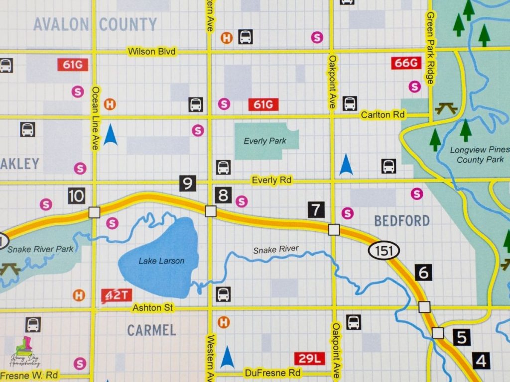
Maps can be drawn so many different ways so keys and symbols make them easier to understand. Dig out a city or an area local to you map, in the UK OS maps (Ordnance Survey) are great for this as they have a fantastic key that shows everything from different types of churches to picnic benches and more.
We have a fun activity to show the importance of this so check out our Map Symbols and Keys Activity to have some fun whilst learning about this important feature of maps.
Learn with the Atlas
Atlases are fascinating books like maps we have a few in our house and use them from a very young age to learn about the world.
We have a whole set of Atlas-themed activities as well as our favorite Atlases that are great for your homeschool that you and your kids will love for many years. So check out the information by clicking on the blue underlined links.
The World Map
Finishing off with maps it’s time to explore the world before you head over to our unit study on the Continents, Countries, and Oceans of the World which will help your kids get a broad overview of the world around them. Subscribe below to get our FREE printable Continent Colouring Sheet and Continent Fact Files these are a great starting point when looking at world maps, the continents and oceans.

